Why the term “Protected Areas”?

We generally describe PAD-US as the official national inventory of parks and other protected areas, reflecting the expansion of PAD-US to cover all types of lands secured for long term and open space uses. Some refer to it as a public or managed lands database. Others for Federal land ownership. All are relevant. “Protected” has often meant “for conserving natural biodiversity,” but that meaning has expanded to embrace the full range of the lands in PAD-US – from local parks all the way to huge Wilderness Areas and much more.
What’s with all the “unknown” owner/managers?
We’re working on this and it’s getting better! It turns out that source agency data from Federal agencies is often focused on managers and the ownership field information is not always known or filled out – same with some States. PAD-US also allows for a local name for an owner/manager and some of these are still unknowns, too. The PAD-US Data Manual calls for all these to have functional values and we look forward to those improvements.
Some National Park lands are designated as Marine Protected Areas?
Yes, really! In this case, agencies nominate sites for inclusion in the MPA system and those accepted by the NOAA MPA Center receive the additional designation ‘MPA’, even though most of their area may be on land (e.g., Olympic National Park). PAD-US continues to evolve – when we discover anomalies that may seem incorrect, PAD-US works with source agencies to understand and adapt accordingly. Let us know if you find issues like these: email pad-us@usgs.gov.
What’s the difference between PAD-US and other U.S. protected areas data sets?
PAD-US is the official national inventory of protected areas, and a National Geospatial Data Asset in the Cadastral Theme (see NGDA Portfolio Community here). PAD-US is the best available U.S. aggregation of Federal land ownership, easement interest, and management designations, as well as of State, local and nonprofit data on protected areas. Because PAD-US is published at longer intervals, individual Federal and other land management agencies are always the best source for the most up to date official information about holdings for particular agencies. For more information about the Federal Lands Work Group, and more on that process at the Federal level, visit the Federal Lands Workgroup page. The following are related datasets that you may come across as well – contact their source organizations for more information:
- Bureau of Land Management Surface Management Agency (SMA) dataset – BLM is the authoritative aggregator of Federal land transaction records. The SMA dataset represents the current status of that aggregation at a given time. The key differences between SMA and PAD-US are that a) PAD-US represents land ownership (where available) and management; b) PAD-US obtains spatial data directly from agency data-stewards (BLM develops SMA from land transaction records submitted by agencies, as they become available); and c) PAD-US includes all protected areas (Federal, State, local, private and nonprofit) with descriptive agency names. SMA is mostly Federal, but includes some generalized State and local data.
- ParkServe – The Trust for Public Land has created a major GIS database of parks and open space lands in all urban areas of the United States. TPL will contribute this data to PAD-US when they complete the inventory work (estimated in late 2018), and they and PAD-US will help States integrate this into their inventories.
- Conservation Almanac – The Trust for Public Land’s Conservation Almanac is a system for tracking conservation finance, including an inventory of individual acquisitions with public tax or bond funding since the early 1990s (not before).
- Conservation and Recreation Lands database (CARL) – Ducks Unlimited created this protected areas inventory for the Great Lakes region, which is now in the process of being phased out and incorporated into PAD-US.
- Secured Lands Database – The Nature Conservancy has developed protected areas data for many eastern U.S. States and some in the Midwest. TNC and PAD-US are discussing strategies for data integration.
When should I use PAD-US vs. State inventories?
PAD-US is best when doing national or multi-state regional mapping and analysis, or for areas that lie across State or other country (North America) lines.
Where States don’t have inventories equivalent to PAD-US, PAD-US may in fact be the best available data. For states that are ranked highly in completeness, working with the State inventory will likely provide the most current data, except that the state may or may not have the most up to date Federal agency data. In those cases, you might use the State inventory for non-Federal data, and PAD-US for Federal lands. Federal lands may have slightly different boundaries in some states due to states’ use of parcel base maps that differ from Federal agency.
How does PAD-US connect to Recreation.gov?
Recreation.gov is the national reservations site for parks, camping and park events, and it is currently developing plans to use PAD-US for its park boundary data.
Where can I go to just browse PAD-US data on a web map?
We’ve got three great resources: 1) The USGS PAD-US Data Explorer, which has some nifty reporting tools for conservation values; 2) the mapper at www.ProtectedLands.net, which has extensive search capacities, as well as tools to create PDF state or custom poster maps. ; and 3) Esri has also published a series of thematic web maps depicting PAD-US.
There’s a crazy pattern of ownership in the Colorado Front Range east of Denver - is this an error in data?
Nope – the land in question is a collection of U.S. Forest Service lands near ski areas that appear to be a jumble of sticks – but those are in fact actual ownership boundaries! The U.S. is a huge place and there are many instances where land ownership or management is in patterns that seem hard to imagine. Another example is the Lake Traverse Reservation, in South Dakota and a bit of North Dakota, that is a perfect triangle. That is also a correct representation of ownership. This is not to say that there aren’t occasional boundary errors and overlaps, but it’s increasingly the case that what’s in PAD-US is actually what exists in ownership.
Why do agencies seem to have many variations in their names?
This is a known issue with local data in particular: State data inventories often come with agency names that are encoded differently (for example: “Town of Oakville”, “Oakville”, “Oakville Town”). Federal agencies have already corrected this issue in their data (‘Mang_Name’ and ‘Own_Name’ fields), and the PAD-US team encourages data-stewards to adopt its recommended practices on agency naming:
- An ‘Agency Name’ domain table, with codes and descriptions, is available in the PAD-US data dictionary (available in the PAD-US Data Manual).. This domain applies to PAD-US ‘Owner Name’ and ‘Manager Name’ fields.
- Review all current agency names and make changes to create a single name for each agency. Even small variations in spacing or capitalization will result in multiple records when querying the database.
- Use proper case capitalization for all agency names (eg ‘Town of Hilton Head Island’ vs ‘Town of’, ‘town of’, or ‘TOWN OF’)
- Make a choice in municipality name format and stick to it across all agencies. For instance, ‘Broward, County of’ vs ‘County of Broward.’
- Track jurisdictional level in an additional field. Recommended domains for an ‘Agency Level’ field of that type are: ‘Federal’, ‘State’, ‘County’, ‘City’, ‘Special District’, ‘Nonprofit’, ‘Joint Agency’, ‘Private.’
For advanced approaches and more detailed examples, see this memo written by GreenInfo Network on the topic (PDF 185kb).
Any cool examples of how people are using PAD-US data to help people find parks and recreation?
Yes! Check out Recreation.gov’s new system, which will use PAD-US for boundaries around most reservable sites, such as campgrounds. You can also see a good example of what complete parks and protected areas data can do at GreenInfo Network’s www.GetOutSideSanDiego.org, a responsive web application for finding special adventures outdoors.
How is PAD-US used?
PAD-US supports various applications across jurisdictions such as wildland fire and transportation planning, emergency management, recreation and tourism, economic assessments, and more.
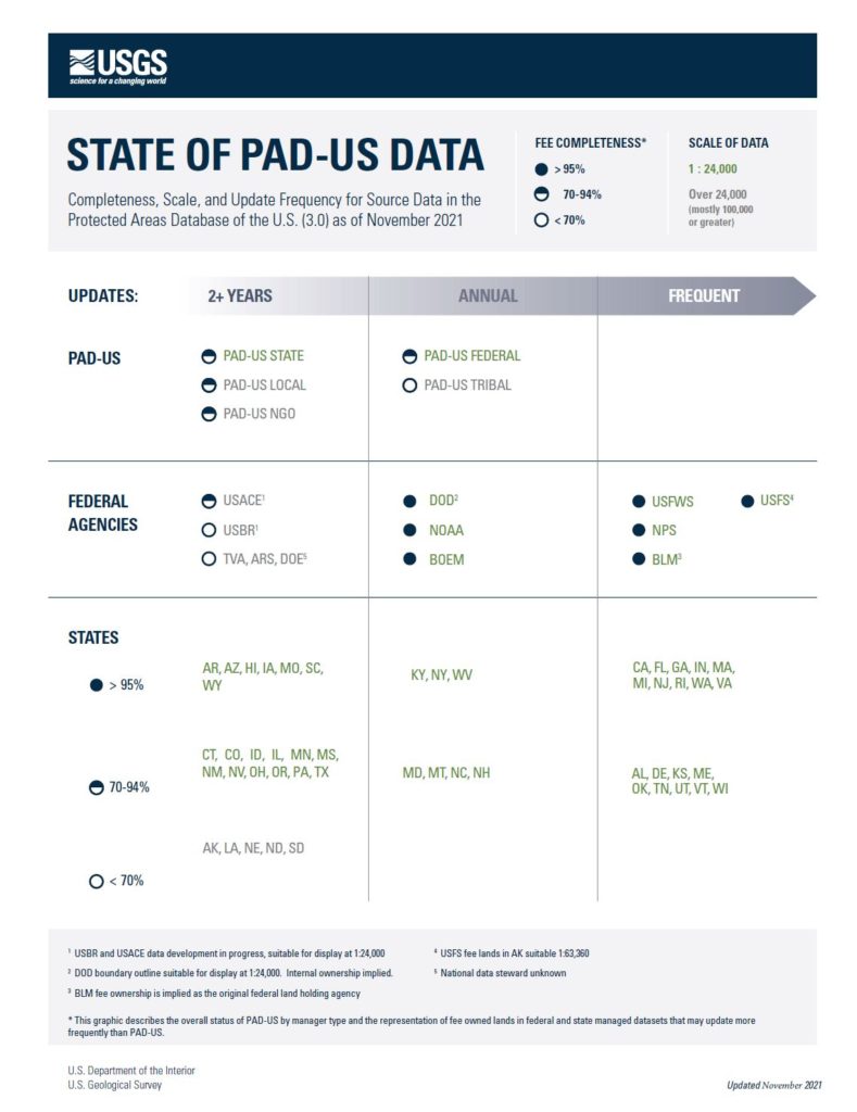
How complete is PAD-US?
The PAD-US team has worked closely with Federal, NGO, and State stewards to assess the completeness, scale, and update frequency of source data. That information is summarized in the graphic below and updated frequently (last updated in November 2021). Watch the Federal Lands Workgroup for the latest updates to this document.
test
test