Introduction

For GIS users, understanding the technical structure of PAD-US is crucial to effective work. Here are some key elements to understand.
For GIS users, understanding the technical structure of PAD-US is crucial to effective work. Here are some key elements to understand.
PAD-US is developed as an Esri Geodatabase with six feature classes of boundaries:
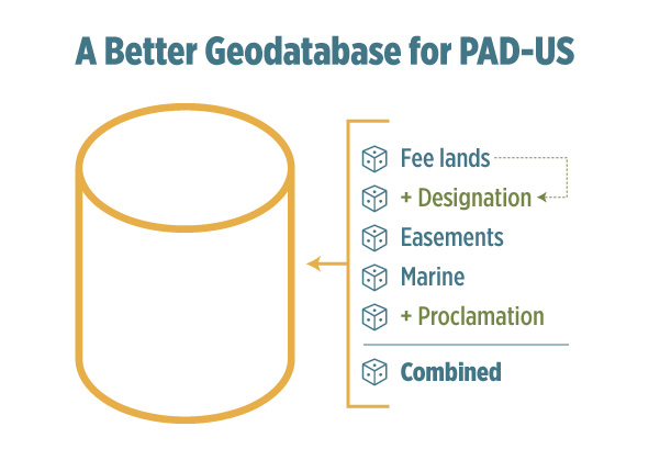
When working with PAD-US Feature Classes, it is important to note that:
The PAD-US database is maintained in a projected Coordinate System:
USA Contiguous Albers Equal Area Conic USGS version (GCS North American 1983)
The horizontal datum requirement is:
Geographic Coordinate System: GCS_North_American_1983
PAD-US data is combined from many sources with varying accuracy, but in general should be reliably accurate at 1:24,000 scale. See the “State of PAD-US Data” graphic on the FGDC Federal Lands Workgroup website for more information.
Agreement on which ownership data to use to define the boundaries of protected areas is limited. While there is a general national goal of a nationwide parcel layer, we are far from this goal. Even in some States, Statewide parcel boundaries may not fully line up with individual county tax parcel agencies’ data – while others have more seamless, integrated parcel data. The same is true at the Federal level where some agencies may use boundaries based on the Public Land Survey System (PLSS) and others use different frameworks. Resolving these issues is a broader challenge being taken up by a workgroup in the Federal Geographic Data Committee.
In addition to the basic issue of parcel alignment, some State inventories are submitted to PAD-US with Federal lands – however, these lands are removed in the PAD-US publication process and replaced with approved data provided by the individual Federal agencies themselves. This is done to ensure that Federal lands are provided through an authoritative process. But the result can be that for States with coordinated parcel alignments, their data in PAD-US may now have Federal lands that are no longer fully aligned with their local data. Users focused just on those States may instead choose to use that State’s comprehensive dataset, but with the tradeoff that it may or may not have the most current Federal lands data.
Finally, while the Federal lands in PAD-US represent authoritative agency data, some Federal agencies do not yet have complete data for all their holdings. These agencies are working on correcting this as resources are available. In a few cases, States may have more complete Federal lands data than Federal agencies – PAD-US users needing high accuracy for such data should coordinate directly State and Federal data sources to resolve such issues.
PAD-US is an aggregated data inventory – it contains scores and scores of data sources which are all integrated into one combined database. The policy of PAD-US is to accept agency data submissions “as is” and simply translate them into the full PAD-US data structure. This means that the boundaries created by any agency or data steward may not fully align with those of another, creating GIS topology errors (mostly overlaps or slivers).
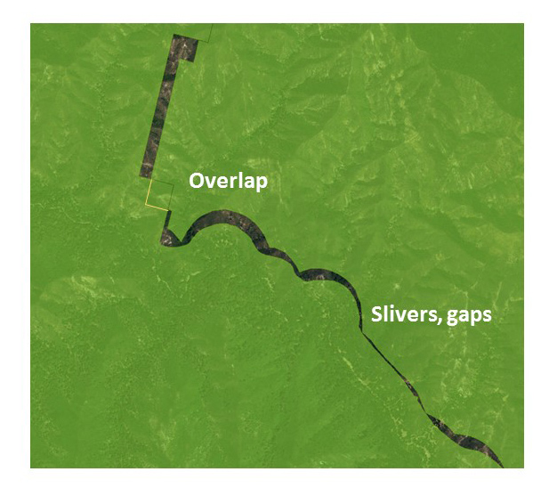
PAD-US has made great progress in reducing incidental overlaps and slivers among Federal agencies and future editions should continue this trend. Agencies are being encouraged and supported by PAD-US to sort out their ownership overlaps and provide clean source data into PAD-US.

PAD-US also has a number of feature classes that intentionally overlay one another – for example, some easements overlay fee lands or other easements; many designation or proclamation boundaries overlay fee and/or easement lands, as well as other designations/proclamations. These are not errors – they’re an accurate reflection of the world of protected areas data. But they can create challenges for GIS users. Designations and proclamation boundaries are in separate feature classes which has helped address this issue, but the fact remains that overlapping boundaries are a key part of this dataset.
There are approximately 30 core fields in each PAD-US data layer, divided between fields that come from source agencies (‘Local_Owner’, ‘Local_Name’, etc.) and those created by the PAD-US team from domain values (e.g., ‘Designation’ Type) or from defined calculations (e.g., GAP Status Code):
USGS adds value to agency provided source data by managing several additional attributes. The following attributes are assigned categorically by Designation Type or transferred between PAD-US updates when more information is available:
Many of these fields use domain values (standards for populating these fields) established by USGS. You can download a blank schema or spreadsheet containing all domain descriptions from the PAD-US Data Manual. Users are encouraged to explore this PAD-US Data Manual to learn more about these fields and domain values.
Designation Type Questions:
What is the difference between Local Park and Local Recreation Area?
Generally, Local Parks are parks by name. There is a bit of a gray area with Local Parks and Local Recreation Areas. The general rule is a Local Recreation Area should be a more developed site, specifically for human oriented intensive recreation activities. In that sense, anything “Playground / Tot Lot / Skate Park / Court / Field / Swim Center / etc.”, would be a Local Recreation Area because it is a stand-alone area dominated by an intensive recreation activity. Most of these examples would normally not be followed by “Park” in the name, except in some cases (like Skate Park, which is properly assigned to Local Recreation Area). However, areas like Community Parks, City Parks, County Parks, Dog Parks, Marina Parks, etc., should be designated as Local Park because they are not necessarily places that are developed specifically for or dominated by intensive recreation activities.
Why are proposed Wilderness Areas included in the standardized Wilderness Study Area designation type?
While proposed or recommended Wilderness is not legally the same thing as a congressionally designated Wilderness Area, they are managed similarly and are grouped together for PAD-US purposes. See ‘Local Designation Type’ for the official designation type provided by managing agencies.