A June 2016 article in the Proceedings of the National Academy of Sciences (PNAS) (“Achieving climate connectivity in a fragmented landscape”, McGuire, et al) reports on new methods that ecologists can use to determine the most effective regions for habitat connectivity. The particular focus of this reasearch is climate connectivity, “…the spatial configuration of natural lands allows species to track their current climatic conditions during projected climate change.”
This research used PAD-US gap codes (biodiversity protection levels) to define “natural lands” which were then used to assess habitat corridors in relation to climate change in landscapes. By examining these climate change-rated corridors in relation to protected lands, researchers and policy makers can better focus conservation resources to protected lands that fill in this corridor pattern.
The report’s summary states:
“The contiguous United States contains a disconnected patchwork of natural lands. This fragmentation by human activities limits species’ ability to track suitable climates as they rapidly shift. However, most models that project species movement needs have not examined where fragmentation will limit those movements. Here, we quantify climate connectivity, the capacity of landscape configuration to allow species movement in the face of dynamically shifting climate. Using this metric, we assess to what extent habitat fragmentation will limit species movements in response to climate change. We then evaluate how creating corridors to promote climate connectivity could potentially mitigate these restrictions, and we assess where strategies to increase connectivity will be most beneficial.
By analyzing fragmentation patterns across the contiguous United States, we demonstrate that only 41% of natural land area retains enough connectivity to allow plants and animals to maintain climatic parity as the climate warms. In the eastern United States, less than 2% of natural area is sufficiently connected. Introducing corridors to facilitate movement through human-dominated regions increases the percentage of climatically connected natural area to 65%, with the most impactful gains in low-elevation regions, particularly in the southeastern United States.
These climate connectivity analyses allow ecologists and conservation practitioners to determine the most effective regions for increasing connectivity. More importantly, our findings demonstrate that increasing climate connectivity is critical for allowing species to track rapidly changing climates, reconfiguring habitats to promote access to suitable climates.”
An example map from the article showing the corridors ranked by efficiency:
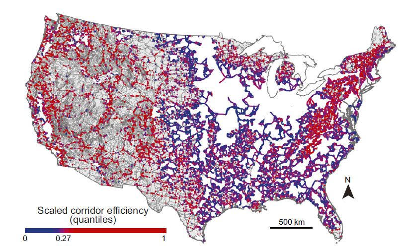
Corridor efficiency scaled to the maximum value. Patches are gray, and corridors are blue to red from highest to lowest relative efficiency. Corridor efficiency measures how challenging it is to traverse the corridor due to human impacts and the thermal gradient per kilometer of corridor. More efficient corridors are less challenging to traverse and may be less expensive to conserve and restore because they generally have lower human impacts.