A Resource for the Protected Areas Database of the United States (PAD-US)

Category Archives: Uncategorized

Latest PAD-US Data and Tools

Version 3.0

Version 3.0 of the Protected Areas Database of the United States (PAD-US) has been released. Data is available for download nationally, by 12 Department of the Interior (DOI) regions, or 56 State/Territory boundaries. The data is provided in several file types including geodatabase, shapefile, geopackage, GeoJSON, or KMZ.

U.S. Geological Survey (USGS) Gap Analysis Project (GAP), 2022, Protected Areas Database of the United States (PAD-US) 3.0: U.S. Geological Survey data release, https://doi.org/10.5066/P9Q9LQ4B.


PAD-US Data Explorer

USGS launched the Protected Areas Database of the United States (PAD-US) Data Explorer.  This online map application allows users to view web maps and chart statistics of areas that are protected for biodiversity conservation, as well as lands and waters that provide public access to nature.


PAD-US Statistics Dashboard 

USGS is providing a PAD-US Statistics Dashboard.  This dashboard provides a way of interacting with PAD-US data by leveraging spatial data from PAD-US into tabular and chart format. It enables users to quickly visualize information from acreage to ownership and landscape composition in an accessible format at a (coarse) national scale all the way down to a (granular) county scale.


Poster Maps

PAD-US 3.0 poster maps are available to increase awareness of PAD-US and aid user interpretation. The maps provide a general overview of management, not ownership, as Federal and other designated areas may overlap state, private, and other inholdings. The maps include U.S. States only (not Territories) based on the PAD-US 3.0 Combined Proclamation (Tribal areas and military lands are provided for context), Marine, Fee, Designation, Easement feature class, published by the USGS Science Analytics and Synthesis (SAS), Gap Analysis Project (GAP).


GAP Status Assignment Tool

An online tool that allows PAD-US Data Stewards to determine GAP Status Code for a protected area is now available. GAP Status Codes are a measure of the conservation type of each parcel based on protection level categories that provide a measure of management intent for the long-term protection of biodiversity. User provided GAP Status Codes are preferred but can be categorically assigned using designation type and a crosswalk created in collaboration with data stewards.

Read more
Esri Web Services and PAD-US (15 min. video)

Rich Nauman of Esri presents on how Esri web services have been applied to PAD-US data, creating many options for using PAD-US in web applications and on desktop GIS systems.  This is part of a broader presentation on PAD-US and runs just under 15 minutes.

Here’s the video (opens in new window from Google Drive, .mp4 file) >.


Read more

Protected Areas Data Guidance for Web Base Map Developers (and others)

UPDATE:  For the most recent edition of the Base Maps memo, visit the Federal Lands Working Group website and view the PDF document noted in the right column (the memo is regularly updated).

After months of development and review through the Federal Lands Working Group, July 2019 brought the first edition of technical guidance on how to use PAD-US and federal managing agencies’ protected areas data, aimed primarily at those working on web base maps (but also useful for others).

Called How to Use Protected Areas Data in Base Maps – Guidelines for Incorporating Public Park and Related Protected Areas Data for the U.S. into Online Base Maps, the paper explains the nature of protected areas data, how federal agency data is managed, and overall caveats about uses. For PAD-US and for each of eight federal land/water managing agencies (plus the Census Bureau), data sets are described, guidelines noted, and sources and contacts indicated. This information includes the Marine area managing agencies, BOEM and NOAA, as well as all the land managers (BLM, USFS, NPS, FWS, etc.).

The PAD-US team, including USGS staff and GreenInfo Network, developed the guidance draft, bringing into one place much information that was previously only available by finding multiple information sources. Each federal agency then reviewed their summaries and provided the most current contact and data access information.

A number of web map developers, including Esri, Google, as well as recreation map developers, and even the USGS National Map team are putting this information to good use, as the work to incorporate the newly released PAD-US 2.0 into their web products.

Related to the memo is the recently published PAD-US Help system, available at www.protectedlands.net/helplearn more here.

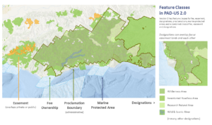
PADUS 2.0 Feature Class Graphic Image of memo cover

Read more