PAD-US Vision

A single, continuously-updated geospatial database that allows users to find exact boundaries and essential attribute information for every public park and other protected area in the United States.
This vision is the long term goal for PAD-US, and much progress has been made in achieving it. It is the intention of the PAD-US team that by 2020, the United States has a complete database of protected areas and is set to maintain and improve that data into the years after.
The PAD-US Action Plan report (November 2016) defines the way forward to completing and maintaining PAD-US – download the report here.
Upcoming Data Updates
With the announcement of PAD-US version 2.1 in September 2020, the road map for the near term future includes these priorities:
- Include Trust for Public Land’s ParkServe data, which is an inventory of all urban parks in the U.S. This would include sharing data back to State data-stewards as well.
- Improve Federal agency topology, as well as update holdings data.
- Secure review of Federal agency data for conservation measures (‘GAP Status Codes’).
- Updates from selected States that can contribute their own data to PAD-US, and selected other States where assistance can be provided.
- Annual updates from the National Conservation Easement Database.
- Improvements to database and processing technologies used in the production of PAD-US.
Road Map for Beyond
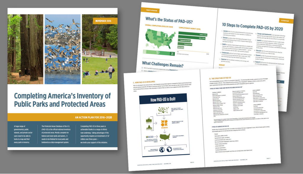
PAD-US is developed in collaboration with a strong network of Federal, State, and nonprofit agencies and organizations, with overall management by USGS. The PAD-US team outlined its future priorities in an Action Plan, available here, which will continue to guide work in the coming years. For this future, the top PAD-US priorities are:
- Anchor PAD-US as the national framework for protected areas inventories and maintain its current operations, in addition to undertaking new initiatives.
- Extend the efforts of the FGDC National Boundaries Group/Federal Lands Working Group to better integrate Federal agency land data into PAD-US.
- Build the capacity of State data-steward organizations to complete and maintain State inventories by facilitating the public and foundation funding of this work, or incentives in related programs — such as close coordination with the Land and Water Conservation Fund (LWCF) State assistance program.
- Collaborate with the Trust for Public Land’s ParkServe project on improving local and regional park data in urban areas, while also involving and supporting State steward organizations.
- Improve PAD-US attribute consistency and coverage, and geometric accuracy.
- Design and implement a next-generation technology approach that will enable improved data analysis and reporting, and make PAD-US more efficient to use generally.
- Launch core outreach initiatives for users in: public health, conservation and climate adaptation, wildfire management, multi-jurisdictional collaboratives, commercial mapping companies and application developers, and RIDB/Recreation.gov, among others.
- Educate PAD-US current and potential users about the availability and best uses of PAD-US data.
- Expand the PAD-US partnership framework (State, Federal, NGOs) to support and encourage PAD-US development, including public, private, and academic interests.
- Support NCED for developmental and ongoing work on conservation easements.
How You Can Help
PAD-US is a collaborative effort, and relies on information from data-stewards and users alike. Tracking how PAD-US has been utilized in research, conservation analysis, web maps, and other applications helps us understand how to continue to improve PAD-US. Data uses are often highlighted on ProtectedLands.net.
The PAD-US team relies on close collaboration with partners and stakeholders. If you have used PAD-US in your work, have suggestions or questions, or would like to receive regular updates about PAD-US, please reach out to Lisa Johnson, PAD-US Coordinator / FGDC Federal Lands Working Group Co-Chair, at pad-us@ugsg.gov or lisajjohnson@boisestate.edu