What to Know Before Using PAD-US Version 2.1
Overall Use of PAD-US

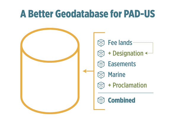
- The PAD-US geodatabase has five individual feature classes and a combined feature class. Individual layers include ‘Fee’, ‘Easement’, ‘Designation’, ‘Marine’ and ‘Proclamation’ (more below). The ‘Combined’ feature class includes overlapping designations (e.g. Wilderness within a National Forest) and users are encouraged to read metadata before use.
- Many ArcGIS layer files are provided with the data set download (MXD) and it’s best to use these initially for display and as queries.
- There are still some slivers and overlaps in PAD-US Fee, but the good news is that there are far fewer than previously, and work is underway to continue to reduce these issues. In particular, we continue to work with our Federal, State, and non-profit data-stewards on these issues.
- Most easements do not allow public access – only where ‘Access’ is “Open” should they be shown in any public recreation mapping (most easements leave underlying land ownership in private hands) – note that some fee lands are also coded as “Closed” to public access.
- Proclamation (and designation) boundaries are not ownership boundaries – use the ‘Fee’ file to define the specific boundaries of owned lands.
- The ‘Marine’ feature class has two very broad types of areas: Marine Protected Areas (MPAs) managed by NOAA as well as equivalent designations for areas managed by other federal agencies, states, and Outer Continental Shelf areas managed by the Bureau of Ocean Energy Management (BOEM).
Feature Class Categories and Examples
| Feature Class | Description | Example |
| ‘Fee’ | Land owned outright by public agencies, nonprofits, or private entities. | National Forest lands owned by the U.S. Forest Service. |
| ‘Easement’ | Non-sensitive conservation and open space easements provided by the National Conservation Easement Database (NCED). | Privately owned land with a voluntary conservation easement agreement in place. |
| ‘Designation’ | Policy-designated areas that may overlap fee owned land, easements, or other designations. | Legislatively designated Wilderness Areas overlapping federally owned BLM, USFS, FWS, or NPS lands. |
| ‘Proclamation’ | Congressionally designated proclamation, Tribal areas, military lands, and other boundaries providing context for planning or references purposes. Does not represent ownership boundaries. | National Park or National Forest boundaries congress approved for voluntary land acquisition within (boundary does not represent private, state, or locally owned/managed land inholdings). |
| ‘Marine’ | Protected waters, including federal, state, and local areas in the National Oceanic and Atmospheric Administration (NOAA) MPA inventory, as well as Bureau of Ocean Energy Management (BOEM) off shore areas managed for energy and minerals. | National Estuarine Research Reserves |
| ‘Combined’ | Single layer that combines feature classes. | Combinations of the ‘Fee’, ‘Designation’, ‘Easement’, ‘Proclamation’, and ‘Marine’ feature classes. |
A Review of the Individual Data Fields in PAD-US
The Data Manual Tables and Crosswalks workbook that describe all PAD-US geodatabase domain codes and descriptions (e.g. Agency Name, Designation Type) as well as the crosswalks used to format source data into the PAD-US schema (e.g. Local Agency to Agency Name, Local Designation Type to Designation Type, Designation Type to GAP Status Code and IUCN Category) can be downloaded here.
1) How is the ‘Category’ field best used?
‘Category’ is a very useful first level organizer for PAD-US data and defines these types: ‘Fee’, ‘Easement’, ‘Designation’, ‘Unknown’, and ‘Other’.
2) Designations are very useful but it’s crucial to understand how they work.
Designations in PAD-US are not ownership layers and show policy boundaries (such as Wilderness Areas and National Monuments) that may overlap lands owned in fee (such as National Forest lands). Because these boundaries are based in laws and regulations, they also may not align with fee ownerships. However, the ‘Designation’ feature class is extremely useful in determining how an area is managed.
3) Some federal agencies do not have all of their lands in their national GIS inventories – here’s how we handle that:
If any agency does not have information on their lands owned in fee, managed lands might go in either the ‘Designation’ or ‘Proclamation’ feature class. However, in order to present as close to accurate footprint of fee managed lands as possible, some of these lands are represented in the ‘Fee’ feature class. For example, a major National Park will show ‘Designation’ in the ‘Owner Type’ and/or ‘Owner Type’ fields.
4) For Federal agencies, ‘Unit Name’ and ‘Local Name’ seem inconsistent – how are these defined?
Unit name can be the official agency identifier which supports administrative process for the agency with Local Name often being a more commonly used name – but not always (PAD-US team is working on this for the future). For the National Park System, for example, the ‘Unit Name’ is the common name (Badlands National Park) and the ‘Local Name’ is the internal NPS abbreviation for the park (BADL). For BLM, a ‘Local Name’ might describe National Public Lands associated with a specific field office, while the ‘Unit Name’ would be the more generic ‘National Public Lands’. For Fish & Wildlife Service, ‘Unit Name’ can be the internal tracking name (‘Jameson Island’) while local name can be the common name (‘Big Muddy National Fish and Wildlife Refuge’). For all other (non-Federal) agencies, ‘Unit Name’ and ‘Local Name’ are often exactly the same.
5) By and large, ‘Manager Name’ is more consistently attributed than owner name – why?
Although the PAD-US team has a goal of maintaining ownership information for all fee owned lands, not all Federal or State agencies or non-profits maintain ownership information. In many cases, the source data only included manager information.
6) For local government holdings, here’s how to interpret Owner/Manager naming:
Owner and Manager names below State level are generic – e.g., ‘City Land’, or ‘County Land’. ‘Local Owner’ and ‘Local Manager’ are usually specific to the particular agency (‘Emmet County Parks’), where that information is known.
7) Designations and local designations
Similar to Owner/Manager naming, Designations are generic below the Federal level where they are specific to each agency. State and local agency holding designations are categorical (‘State Conservation Area’, ‘Local Park’, etc.), whereas ‘Local Designation’ is whatever PAD-US source data has for each agency (‘Forest Reserve’, ‘Park’, etc.) – these ‘Local Designations’ are not standardized by PAD-US, though state data stewards may have done that for the data they have contributed. This varies greatly by state.
9) Source fields – how do these work?
‘Aggregator Source’ is the dataset which PAD-US has incorporated into the database per the State, Federal or NGO data-steward. ‘GIS Source’ is the actual file name or other identifier of the data set used by the data steward in the submission to PAD-US. Some stewards will have a number of GIS sources for one (or more) aggregated source data sets. Dates are provided for most.
10) Site IDs – tell me about these
Aggregators can submit unique IDs in their data sets and ‘Source Protected Area ID’ presents that as submitted. ‘WDPA Site Code’ is managed exclusively by the PAD-US team for extracting and submitting to the World Database on Protected Areas select areas highly conserved for nature.
11) Public Access Definitions
PAD-US seeks to classify holdings by whether they are ‘Open’, ‘Restricted’ (permit needed), or ‘Closed’ to public access, or whether that status is ‘Unknown’ (frequently the case, as we work on filling out this attribute in the future). Each holding’s access is sourced with a year date. Sources can be specific agencies or aggregators – they can also be ‘Gap Default’ which is assigned by the PAD-US team according categorical assumptions by ‘Designation Type’. For example, ‘National Parks’ and ‘State Parks’ are typically open to public access, while many private conservation areas are closed to public access.
12) GAP/IUCN Codes
PAD-US tracks two different assessments of biodiversity conservation by management intent: ‘GAP Status Code’ and “IUCN Category’. GAP Status Codes range from 1 (the highest level of protection) to 4 (unknown). ‘IUCN Category’ refers to six management categories established by International Union for Conservation of Nature (IUCN). Note that these assessments do not track effectiveness.
13) Date of Establishment
This date relates to when a unit was first authorized – for example, when a National Park was created by Congress. Subsequent to that date lands may have been added and other attributes shifted, but PAD-US can’t track these time details at this point, so we just use ‘Date of Establishment’.
14) Why is ‘Unknown’ sometimes coded as UNK and sometimes as UNKF or UNKL?
UNK is the generic term in PAD-US for ‘Unknown’ values. UNKF is ‘Unknown – Federal’ and UNKL is ‘Unknown – Local’, both of which are mainly used in the ‘Easement’ feature class, where the NCED data does not always identify Owner Name – distinguishing between federal and local owners extends the usability of the easement data.