Introduction

PAD-US is the authoritative source for questions that apply to more than one agency. Agencies are always the best and official source of their lands data. The most common uses of PAD-US are for national or multi-state regional analysis and mapping. While PAD-US can certainly be used for individual State and local area assessments, it may not be as complete for particular states as statewide data. Check completeness of State inventories here.
Where states do not yet have complete inventories, PAD-US may be useful as both interim data and as a model of how to develop complete datasets.
For almost any use, it can be valuable to learn more about the PAD-US data structure and attributes, to better understand what it can help you do.
Common uses of PAD-US include:
Land Management
Managers of Federal, State, and other resource lands often need to see the context of the landscapes around the sites they steward. Where states don’t already have a full inventory of these areas, PAD-US is a ready-to-use data system to use in both understanding adjacent land and water context, but also can be used to help develop benchmarks drawn from areas around other similar sites.
Conservation of Biodiversity

The origins of PAD-US are in the conservation of biodiversity – by looking at “gaps” in where lands for particular species were protected for long term conservation, scientists, land managers and policy makers could act proactively to prevent loss of species, or to recover where species were endangered. Learn more about the history of gap analysis.
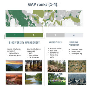
PAD-US continues this core use by providing categorizations of degree of protection for biodiversity conservation which are called ‘GAP Status Codes‘ and are defined as one of four categories:
- Status 1 – Managed for biodiversity with natural disturbance events allowed (for example, Wilderness, Research Natural Areas, some National Parks, some State or NGO Nature Preserves)
- Status 2 – Managed for biodiversity with management that may interfere with natural processes (for example, suppress wildfire or flood)
- Status 3 – Permanent protection, but the land is subject to multiple uses (forestry, farming, intensive recreation, etc.
- Status 4 – No known institutional mandates to prevent conversion of natural habitat types
It is important to note that ‘GAP Status Codes’ provide a general assessment of management intent to protect biodiversity, documented in legislation or management plans. Management intent is determined by categorical assumptions based on designation types, as well as local review when possible. While actual management within individual units may vary, these categorical assumptions provide a transparent, repeatable, and consistent way to measure potential biodiversity protection. But remember that GAP Status Codes do not measure effectiveness of management to protect biodiversity. For example, GAP 3 and 4 lands may still contain important habitat for native or rare species, as well as contribute to habitat connectivity, but GAP Status Codes do not measure indicators such as habitat condition, or track implementation of intended management practices.
While PAD-US ‘GAP Status Codes’ are extremely useful for conservation applications in the United States, PAD-US also supports global conservation analyses. The World Database on Protected Areas (WDPA) is maintained through the World Conservation Monitoring Centre of the United Nations Environment Program and uses PAD-US to define the United States’ contribution to protection of lands for biodiversity, by globally relevant International Union for the Conservation of Nature (IUCN) management categories (these include U.S. conserved lands – ‘GAP Status Codes’ 1 and 2 – that cover as many acres as are in the rest of the world combined and so are a significant element of WDPA).
PAD-US data has also been used to support NAWPA’s analysis on protected areas in North America and is a source for the Commission for Environmental Cooperation (CEC) Protected Areas of North America map and database.
Recreation Needs and Opportunities

PAD-US can be used to assess the presence of local, regional and other recreational parks and open spaces. For example, as PAD-US becomes complete with all local parks, analysis of the walking distance to parks for all of the U.S. becomes feasible.
PAD-US data can also help those building online or print guides to regional, state and national parks and preserves, or in analyzing access to these resources. For example, the U.S. National Park Service in 2018 supported the development of a Federal Recreation Lands Poster that displays a map of the recreation lands and waters managed by seven federal agencies (from PAD-US 2.0 data) on one side and an overview of each agency’s recreation offerings on the other side.
PAD-US can also help with these other recreation-oriented tasks:
- Grant and funding applications: Showing the context of one agency’s lands in relation to all other public park and open space lands can be helpful in proposing funding initiatives.
- Local plans: Countywide park plans that define how to meet an area’s recreation and resource protection needs can be more easily prepared with PAD-US data that identifies existing public open space.
- Park prescriptions: Increasingly, doctors and other medical practitioners are interested in writing prescriptions for park-based physical activity to address chronic disease and improve health – these depend on area-wide parks data like PAD-US in metropolitan areas, covering all types of locations.
- Tourism: Regional and state tourism authorities and commercial recreation-focused businesses can make substantial use of data that has all parks and other open space lands in their area, both for analysis and marketing, and for providing guides to help people visit their area.
- Benchmarks: A national inventory makes park comparisons and benchmarks across multiple jurisdictions feasible, leading to more informed comparisons of how parks can be provided to target populations.
- Park Advocacy: Determining which areas have parks and which don’t is easier with a regional or broader database of parks, like PAD-US.
- Data baseline: PAD-US provides a national baseline for organizing GIS data about parks and open space, informing best practices for all agencies. While many agencies have more extended information about their own parks, PAD-US helps standardize common information that should be in all datasets.
- Web park finder apps: Having a standardized national inventory allows more accurate geospatial data in commercial and other web applications that guide people to parks and recreation.
- Multi-State assessments: A national inventory provides parks and open space data for assessing natural resource and recreation issues that cross state boundaries.
- SCORPs: State Comprehensive Outdoor Recreation Plans (SCORPs), which states prepare to access Federal LWCF funding that often supports local parks, benefit by being based on spatial analysis of where parks are and are not, in terms of meeting people’s need for outdoor recreation.
- Collaboration with public health: Public health departments do community needs assessments. Having a complete understanding of park locations assists in development of public health initiatives – in particular, it can inform efforts to define Safe Routes to Parks strategies.
Land Use Planning
When analyzing where energy facilities or other human uses of lands should be sited, knowing the protection and conservation status of nearby lands is critical. PAD-US can help assess best opportunities in large study regions or along transmission corridors, and can help ensure decisions are better informed and perhaps quicker to reach. While PAD-US is often not a good choice for very specific site analyses (which may require the most current information and great accuracy), it is ideal for regional assessments.
A very good example of PAD-US use is in the Western Association of Fish and Wildlife Agencies’ Crucial Habitat Assessment Tool (CHAT). This map based framework integrates habitat data from 16 western states and provides overlays of PAD-US data to better understand major land use choices.
Wildfire Response

Fighting wildfires requires access to lots of geospatial information, which is used to plan and direct on the ground responses, determine responsibility areas (Federal vs. State, etc.), track historical information for analysis, etc. PAD-US data is a crucial part of this information system, integrated by the National Wildfire Coordinating Group, to provide Federal, State, regional and local land management jurisdiction and management designations for planning team working on fire response.
Base Map Development
Parks and other publicly owned recreation sites are key features in many base map products used in interactive web applications (Esri, Google, USTopo, etc.). Base map providers can use PAD-US as a single national geospatial data set of these lands and waters and supplement with data for particular federal agencies as needed.
The PAD-US Team has worked with the Federal Lands Work Group to develop the guidance document, How to Use Protected Areas Data in Base Maps. This manual offers detailed information on using PAD-US data, federal geospatial data, individual federal agency data sources, and summary information on state data sets. Get the latest version of the report at the Federal Lands Work Group website.
Other Uses for PAD-US
PAD-US can also be used in a wide range of other settings, helping those working on the following types of resources and issues:
- Cultural heritage protection — Protected cultural or historic landscapes are associated with powerful social values. These lands include historic sites (e.g., battlefields, buildings, etc.), parks that showcase the history of human habitation and connections to nature, scenic landscape viewpoints, and other such sites. The role of these areas in fostering understanding and education about our common past is significant.
- Economic development — Lands and waters in PAD-US include those that produce food, wood, fish, and other consumable products. These lands can be analyzed through multiple statistics, including employment opportunities, ecosystem services (like flood management and water quality protection), property values of lands near protected areas, and recreational services income. For example, tourism is a strong element in the economic role of parks and open space lands, including lodging, concessions, guides, equipment suppliers, and many other types of tourism-driven business activity. The National Recreation and Park Association estimates that in 2015, operations and capital spending at local and regional park and recreation agencies generated more than $154 billion in economic activity and supported more than one million jobs. Adding in national and State parks increases the total activity to over $200 billion.
- Hazard mitigation — Lands that have restricted development or that can reduce impacts on developed areas include coastal areas subject to sea level rise, floodplains and buffers, areas susceptible to landslide, wildfire, earthquakes, etc. These areas can be connected to outdoor recreation opportunities as well. Many lands in PAD-US provide these ecosystem services directly or indirectly.
- Human health and well-being — Parks and other open space areas can support human health and well-being. In urban parks, family celebrations and other social interactions and community-building events are well-known to increase overall health. Parks can also help neighborhood identity and involvement. Larger natural landscapes can also play critical roles in psychological well-being and physical health, including providing opportunities for physical activity and enhancing clean air and water.
- Managed resource production — Some public lands support agriculture, forestry, energy, fishing and other managed resource production. These can include national and State forests that are actively logged, grazing allotments, and soil (cropland) and water reserve areas. These lands can also support ecosystem service functions.
- Research — PAD-US can provide valuable data for researchers, including those in academic institutions, State, local, and Federal government agencies, nonprofits, and other organizations. PAD-US has been cited in a variety of peer-reviewed journal articles, reports, and other research on topics including wildfire policy, energy siting, recreation planning, wildlife connectivity, and protected area management challenges.
- Shaping development — Protected lands that form buffers or greenbelts can be used to guide infrastructure and other development into more effective forms, preventing sprawl, providing civic identity, and other such purposes. Many “greenprint” plans rely heavily on access to protected areas data.
- Transportation planning and access — PAD US data can also be used in conjunction with other federal data, particularly where there are shared boundaries. For example, a group under the FGDC Transportation Subcommittee began in work in 2018 to build a consolidated data set containing an inventory of roads on Federal Lands to support mapping, planning needs, resource allocation, land management, recreation, and other uses by members of the Federal Lands Roads Working Group (FLR-WG) (FLRWG). As the official source of aggregated Federal, State, and other managed land boundaries, PAD-US provides context for mapping efforts representing transportation corridors that provide access to public lands. The FLRWG (roads) invited leaders from the FGDC Federal Lands Workgroup (FLWG) to describe lessons learned from the interagency collaboration working with USGS to update the federal estate in PAD-US. This successful partnership is seen as a model for other interagency work groups developing geospatial data.